Google DeepMind has just rolled out the Google Earth AI–AlphaEarth Foundations system, a move that is redefining how we watch and understand the planet. Hailed as a “virtual satellite,” this AI platform will radically alter our capacity to monitor changes in the world’s waters and land.Let’s check out the details with AGIYes.
What’s AlphaEarth Foundations?
AlphaEarth Foundations is a novel artificial-intelligence suite created by Google DeepMind. Instead of relying on conventional satellite imaging, it fuses twenty years of Earth-observation data to build a dynamic digital twin of the planet. The system’s core is a unique data-processing method—compressing raw inputs from satellite imagery, radar scans, 3-D LiDAR, and climate simulations into 64-dimensional “embed codes.”
The technique is akin to assembling a model with LEGO bricks, except the bricks are digital chunks. Every 10 × 10 m patch of the surface is turned into a distinctive data representation that captures the patch’s state and changes across time. In this way, AlphaEarth Foundations offers an unprecedentedly fine-grained portrait of Earth.

Diagram showing how AlphaEarth Foundations works.
What Are the Features of AlphaEarth Foundations?
AlphaEarth Foundations’ power lies chiefly in three areas, each marking a major leap in environmental monitoring.
First, the system delivers stunning detail. It can pierce year-round cloud cover to clarify Antarctica’s complex ice topography and detect subtle shifts in Canadian wheat fields that are invisible to the naked eye. Such acuity is vital for tracking long-term changes like glacier retreat and crop growth.
Second, the platform provides three core modules. A change-tracking module automatically compares historical and current imagery, pinpointing shifts in forest cover, lake area, field boundaries, and built-up land. A resource-assessment module analyses parameters such as groundwater reserves and solar irradiance, offering scientific guidance for crop choice and renewable-energy siting. A data-compression breakthrough turns raw imagery that once required terabytes of storage into lightweight “embed codes,” slashing storage and processing costs.
Third, AlphaEarth Foundations excels in data-scarce settings.
The system can maintain high accuracy even when labelled data or historical records are sparse (remote zones, persistent cloud cover). It fills data gaps via spatiotemporal continuity modelling and delivers reliable forecasts.
Specific capabilities include:
Cloud penetration: restores true ground conditions even under persistent cloud (e.g., tropical rainforests, polar regions).
Temporal interpolation: infers continuous maps for any moment between irregular satellite passes.
Few-shot learning: retains a 24 % error advantage over baselines in regions with scant labels (e.g., African deserts).
These strengths are crucial for monitoring Antarctic ice sheets and Amazon deforestation, areas that traditional methods struggle to cover.

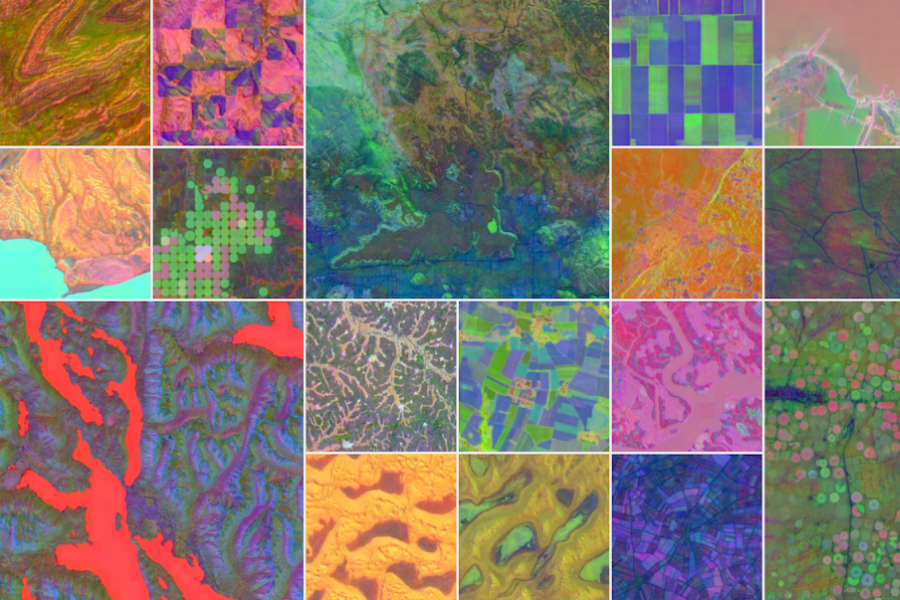
Diagram showing a global embedding field broken down into a single embedding, from left to right.
Application Prospects of AlphaEarth Foundations
AlphaEarth Foundations has broad prospects and will reshape several fields.
In climate action, the system can spot deforestation, wetland loss, and other problems faster and more precisely than ever. Brazil’s MapBiomas project already applies it to analyse Amazonian change, providing solid evidence for environmental policy. Governments and NGOs now gain near-real-time proof of environmental change, sharpening the timeliness and accuracy of decisions.
For food and water security, the platform’s groundwater and solar datasets help farmers optimise crop choice and planting sites, cutting waste. The Global Ecosystems Mapping project is using these data to classify coastal shrublands and hyper-arid deserts, offering new ideas for water-resource management.
To accelerate scientific research, Google will release a “satellite-embed dataset” on the Google Earth Engine platform and offer grants up to USD 5 000. This move is expected to spur researchers worldwide to build further innovations.
Despite its power, users should note several key points.
Privacy: Google states that the system was designed with privacy in mind; its resolution cannot resolve individual faces or licence plates, easing public concern.
Accuracy: Tests show AlphaEarth Foundations beats comparable AI systems by an average 24 % lower error, yet Google still advises independent verification of critical data. Cross-checking multiple sources before major decisions remains best practice.
As AlphaEarth Foundations continues to improve and spread, humanity’s ability to perceive and monitor the planet will reach a new level. The system is not merely an inventive AI application in environmental science; it is a powerful new instrument for tackling global environmental challenges.